When people ask me for hiking recommendations, they often temper the request with three criteria: easy access, moderate difficulty and maximally impressive views. As we head into a shoulder season between peak summer and peak foliage, I find myself itching to hike in the White Mountains, a destination clogged with tourists during the busier parts of the year. Luckily, the Boulder Loop Trail – on a low shoulder of the Moat Range just across the state line in Albany, New Hampshire – is a chance to get into the Whites that also meets these criteria.
The trailhead for the boulder loop is just across the Swift River from the Kancamagus Highway, near the entrance to the Covered Bridge Campground. To access it, the most straightforward route is to follow the Kancamagus Highway from where it leaves Route 113 in Conway – it’s just over 6 miles from that intersection to a right-hand turn onto the Albany Covered Bridge. After crossing the 161-year-old bridge, another right puts hikers right at the parking lot for the trailhead. As with other recreation areas off the highway, there’s a $5 fee for a day-use pass to park in the lot. It’s a bit over 90 minutes to the parking lot from the greater Portland area.
From the parking area, you’ll head away from the river and into the woods. After a quarter-mile, the trail forks – take a left to tackle the hike in a clockwise loop. From here, the route begins to climb somewhat steeply, winding through thick trees and up occasional switchbacks. As you climb, you can see a dramatic cliff face to your right – the top of this cliff is your destination, a low spur on the Moat Range. With a rise of 1,000 feet over less than a mile and a half, it’s a bit more of a workout than you might expect from a short loop.
Also striking in the early part of the trail are the massive granite boulders that give the loop its name. More than just a blockfield of small rocks, the boulders tower above hikers on either side of the route. While the trail deftly weaves between the granite giants, the smaller ones provide some fun scrambling for kids and adventurous hikers.
As you ascend out of the deciduous forest and into the conifers, the boulders get larger and the trail gets steeper. About three-quarters of a mile from the trailhead, you get the first outlook to the south over the river and highway below, and a closer look at the ledges that top the hike to your north. The trail then doubles back, veering away from the sheer ledges to approach its terminus from the back. At this point, be careful to follow the blazes and stick to the trail – multiple footpaths climb along the ledge but are unmarked and often dead-end at rocks or dropoffs.
Climbing north through a mixed forest of spruce and maple, there’s a view west of the Passaconaway Valley toward Livermore and Hart’s Location. Steeply climbing back toward the ridge, you’ll reach a spur trail that leaves the loop (if you’re keeping track, this is about a half-mile from the last overlook, and roughly a mile and a quarter from the trailhead). A short ascent leads to something of a plateau – flat granite slabs with sparse vegetation.
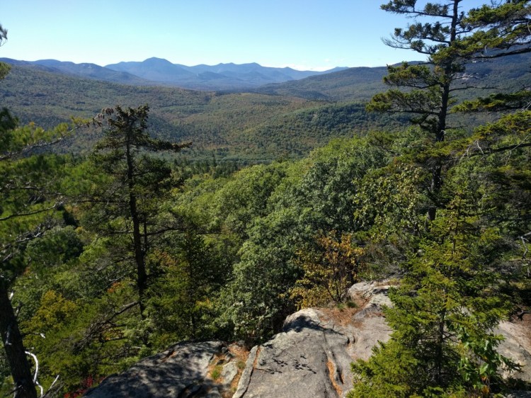
Here, all the work of the climb pays off, with a panoramic view to the south. Mount Chocorua and Mount Passaconaway are the most prominent views in the range opposite the river and highway, but the Ossipee Range, Blue Mountain, the Three Sisters and Bear Mountain are also visible. The ledges drop about 200 feet to the forest below, offering dramatic and unobstructed views below.
Tracing the spur back to the main loop trail, a turn to the right begins your descent. The hike down on the eastern side of the loop is much easier than the climb up, helped in no small part by dozens of granite steps laid into the mountain. The stairs were sourced from the nearby soil and boulder fields, excavated and installed with hand tools and rigging equipment.
Below the staircases, the trail flattens out and winds again through fields of boulders. Interestingly, the remains of charred trees and stumps are also there, evidence of a 325-acre forest fire in the area in 2016. About a mile and a half from the ledges, you’ll hit the trailhead and parking lot.
For the more ambitious hiker, a 3-mile loop may feel like more of a warmup than a full day’s hike. Luckily, you can find more options nearby to tack onto an itinerary. Eight miles further west on the Kancamagus is the trailhead for a personal favorite. The 5-mile loop climbs Little Hedgehog Mountain, and provides three points of prominence with views to north, east and south. A dozen miles beyond that is the Greely Ponds Trail, which moseys around two picturesque ponds. A 4.4-mile out-and-back trail over very little elevation gain, it’s a great warmup or cooldown to pair with a more strenuous hike.
Josh Christie is a freelance writer living in Portland. Along with his brother, Jake, he writes about great Maine destinations for outdoors enthusiasts. Josh can be reached at:
joshua.j.christie@gmail.com
Comments are not available on this story.
Send questions/comments to the editors.


