Let the hyperbole begin.
New England is bracing for “paralyzing, crippling blizzard conditions” as another winter storm threatens to dump 1 to 3 feet of snow in some areas Monday night and Tuesday, forecasters said Sunday.
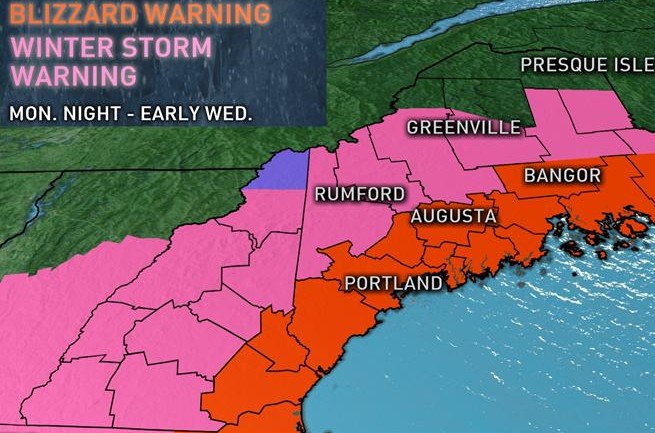
In Maine, 1-2 feet of snow could fall before all is said and done, according to the National Weather Service office in Gray. A blizzard warning was issued Sunday afternoon for many parts of Maine, including Kennebec County, from 10 p.m. Monday until 4 a.m. Wednesday.
The prediction for central Maine from Augusta north to Somerset, Franklin and Waldo counties is for 18-24 inches of snow, the heaviest coming during the daytime Tuesday, meteorologist Eric Sinsabaugh said Sunday.
“Right now our best information is showing a general one to two-foot snowfall across the area,” Sinsabaugh said at about 3 p.m. Sunday. “You’ll see lesser amounts to the north. Highest amounts will be along the coast.”
The first storm on Saturday, which dusted central Maine with a couple of inches of snow, was just a drive-by compared to what’s coming. Social media is all a-twitter about the storm that could intensify “into a monster” as it moves northeastward Monday.
“This storm definitely has the capability of being not only historic but also catastrophic,” Benjamin Sipprell, meteorologist with the National Weather Service in Taunton, Mass., told the Boston Globe.
The clipper system that brought snow to the Ohio Valley and mid-Atlantic Sunday and Monday will transition to a strong nor’easter late Monday into Tuesday, according to the National Weather Service. Heavy snow and strong wind and blizzard conditions are possible in parts of the northern mid-Atlantic and New England. A blizzard watch was in effect Sunday for Long Island and coastal Massachusetts. Winter storm and blizzard warnings stretch from Boston to Maine.
“This is going to be a big one, historic,” Weather Channel coordinating meteorologist Tom Moore told media outlets Sunday. “There could be paralyzing, crippling blizzard conditions. They’re going to be talking about this one for a while.”
For snowmobile enthusiasts, the forecast is good news, and that’s no exaggeration.
“Looks promising — looking forward to it,” the Solon Snow Hawks Snowmobile Club posted on their Facebook page Sunday, showing a map of Maine and colored areas of predicted snowfall. The Maine Snowmobile Association, based in Augusta, posted the same map, adding their own hashtags: #snowbomb and #snowmobileME.
“They’re ready,” Phil Wacome, vice president of Skowhegan Sno-Hawks said Sunday of the snowmobile trails. “We’ve been out trimming the last week or two. We’ve been ready. We just need snow so people can ride. It feels great to finally get some snow. A lot of people have been waiting to connect to northern trails, Right now we’re trailering our sleds, which is more costly.”
Wacome said trails have been good in northern Somerset County, but they could always use more snow.
“The Forks is great. I’ve been up there riding. The Forks north to Jackman and Pittston Farms, it’s all good. Their trails are in excellent condition, but this upcoming snow is just going to be a plus for them,” he said.
Up U.S. Route 201 north of Skowhegan, Leo Hill, trail master for Valley Riders snowmobile club, said he is keeping his fingers crossed that the prediction for a foot or more of snow is going to happen.
“Yes, hopefully,” Hill said Sunday by phone from Gateway Recreation and Lodging. “There’s hardly anything here right now. Hopefully we get it. I tend to not believe it until I see it. We’ll be able to get everything back open. This last weekend I basically had one cabin rented. After the snow it should fill right up. People are already calling because they think there’s a storm coming and they’re making reservations.”
Sinsabaugh, at the National Weather Service in Gray, said the snow should arrive in central Maine after midnight Monday and into Tuesday morning, fairly light to begin with, but picking up quickly after daybreak Tuesday.
“The storm is forecast to slow over the Gulf of Maine, so it’s going to sit there right through Tuesday,” he said. “We’ll probably see snow winding down Wednesday morning, but we could see several more inches on Wednesday morning before things finally shut down.”
Doug Harlow — 612-2367
Twitter: @Doug_Harlow
Send questions/comments to the editors.


Comments are no longer available on this story