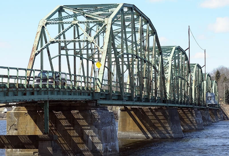
RICHMOND — The deteriorated 80-year-old swing bridge that takes traffic across the Kennebec River between Richmond and Dresden is targeted for replacement in 2013.
As part of the preparation for its replacement, archaeologists have been investigating what’s beneath the ground at the bridge site.
They’ve dug into some much older, significant artifacts that show the site was previously home to not just one, but likely two, old forts — one dating to about 1720.
Historians had a pretty good idea the site on the Richmond side of the bridge was also the approximate site of the second Fort Richmond, built starting in 1740 and standing until it was dismantled in 1955. But evidence dug up by archaeologists at the site indicates it could also be the location of the previous Fort Richmond, the location of which had thus far been unclear.
“So far, we definitely have the site of the 1740 to 1755 fort,” said Leith Smith, an archaeologist with the Maine Historic Preservation Commission. “But there is also clear evidence of rebuilding, of a stone wall built over rubble. That would indicate a period of demolition and rebuilding, which may well indicate that the early fort may be on the same location.
“That’d be one of the questions we’ve been trying to answer. The location of that particular fort has been controversial. It hasn’t really been known where that was.”
Smith, who spent time last summer digging with colleagues on Route 197 as it approaches the span in Richmond, plans to return later this summer to continue tracing out the remnants of the fort’s old palisade walls.
Those walls appear to have been longer than previous documentation indicated — 215 feet long, compared to the previously thought 96 feet.
“We were very excited to find a section of the palisade, which would’ve gone around the fort,” Smith said. “Once you have that, you have the opportunity to trace that out and find the perimeter of the fort. That’s key. There’s a great deal still to learn at the fort.”
Smith said he doesn’t anticipate that any archaeology work will slow down the bridge rehab — even if the site is listed on the National Register of Historic Places, which he hopes will occur.
He said crews will work to examine and document the site before it’s disturbed for construction of the new bridge, near or on the site of the current span.
The swing span bridge itself — a section of which rotates horizontally until it is parallel to the main river channel to allow boats to pass through — is one of only a handful still in use in Maine and was unique in its time. It was built in 1931; all such spans were built between 1901 and 1954.
But its days appear numbered.
State transportation officials looked into repairing the bridge — known within the state Department of Transportation as the Maine Kennebec Bridge — or replacing it with a new low-level swing-span bridge, but rejected both options as too expensive.
In 2007, DOT officials said it would cost $25 million to repair the bridge or $31 million to replace it with a new swing span bridge.
Officials now plan to replace it with a span high enough to allow boats to pass beneath, at a cost of about $22 million.
Construction is expected to start in the summer of 2013 and take two construction seasons to complete, according to Mark Latti, state Department of Transportation spokesman.
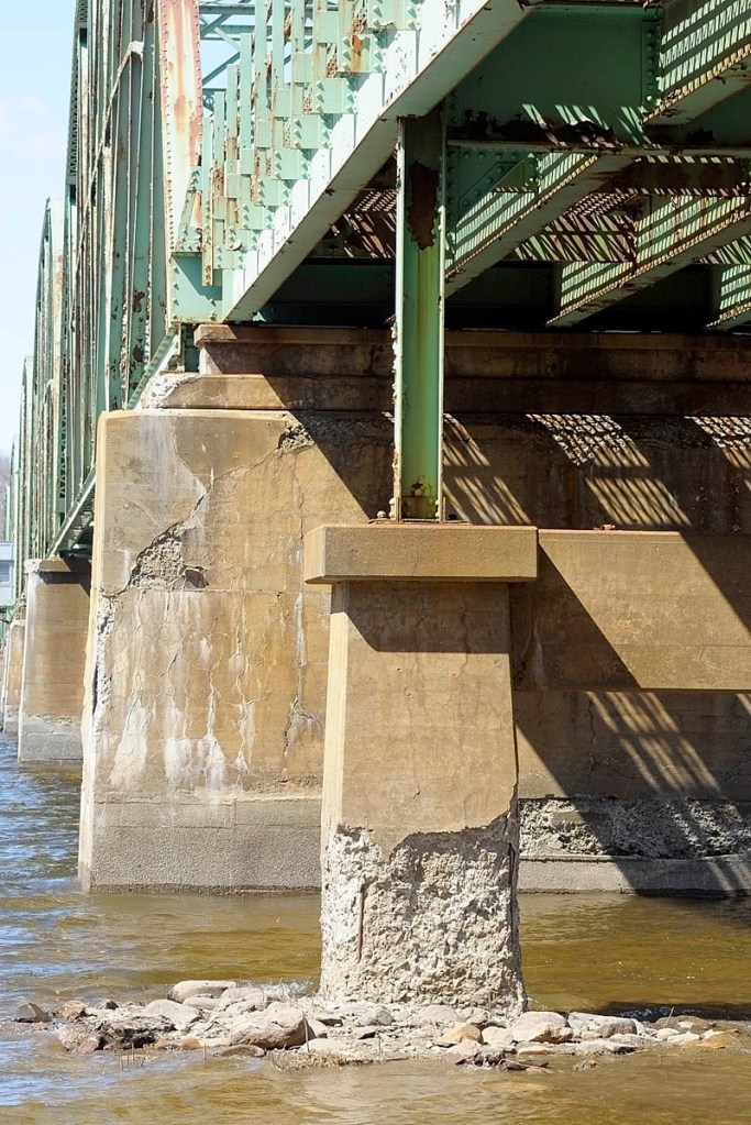
The narrow sidewalk-less bridge’s concrete piers appear to be crumbling. Its green steel sections are rusted in many areas and dented in others.
“It is still safe to use, but it’s showing its age and does need to be replaced,” Latti said.
A state bridge inspection report describes the 1,239-foot span’s structural condition as poor; its superstructure, deck and approach conditions as fair; and channel condition as good.
While DOT officials previously suggested the new bridge could likely be built just north of the current one, they are now saying the location of the new bridge, and whether the old bridge will remain open during construction, has yet to be decided.
Latti said the DOT plans to hold an as-yet-unscheduled public hearing late this summer or early fall to seek public input on the design and location of the replacement bridge.
Then, in the fall of 2012, the bridge design would be put out to bid and construction would start in the summer of 2013.
Latti said funding for the project, consisting of a combination of state and federal dollars, would be included in the state’s next capital work plan.
Local historian Jay Robbins, a former town manager of Richmond, said the bridge was the first one in that location.
Previously, people crossed the Kennebec between Dresden and Richmond by a ferry pulled across by underwater cables.
In 1936, several sections of the bridge took a trip a short distance downriver, after an ice jam lifted some sections off their piers, including one section photographed off the head of nearby Swan Island.
Despite being a historian and appreciative of the current bridge’s appearance, Robbins said he understands why it’s slated to be replaced.
“It would be a change, but I don’t see that it’s a huge issue, given the inadequacy and cost of maintaining the current bridge,” Robbins said. “The bridge that is there is clearly inadequate, and presents issues for pedestrians, horses, bikes, even large trucks. And it is well over 50 years old, so it is probably past its engineered useful life.”
Large trucks and recreational vehicles have to drive down the center of the bridge, which is just 20 feet wide, to avoid hitting bridge cross members that are lower on the sides of the bridge than in the center.
The bridge, according to a sign attached to a dented steel beam at the bridge’s entrance on the Richmond side, has a clearance of 11 feet on the sides and 15 feet, 3 inches in the middle. Some 3,200 vehicles a day use the bridge, according to Latti.
English settlers built a fort, later named Fort Richmond, for protection from Indians and the French around 1720, according to “Richmond: A Long View 1823-1973,” which was put together by the Book Committee of the Richmond Historical and Cultural Society in 1973.
It would be the first of two Fort Richmonds. The first included a stockade enclosing buildings for troop quarters and trade with the Indians. As the threat of Indian wars appeared to be over, the fortification was allowed to deteriorate until 1740, when a new larger Fort Richmond was authorized in response to new hostilities.
The waterfront fort, with 10 cannons, commanded three river channels — the upriver channel, as well as channels to the east and west of Swan Island.
Keith Edwards — 621-5647
kedwards@centralmaine.com
Send questions/comments to the editors.


Comments are no longer available on this story